Seven historical markers stand in Fairview. Most people drive past all of them. Between them they carry an iron furnace, a roadside tavern, a planned town that failed twice, a schoolhouse, a graveyard, two Confederate units, and the woman who planted the park.

Here is where each one is and what it records, with a map under each so you can find it rather than take our word for where it stands. The wording quoted below is the markers' own.

1. The last of Williamson County's iron

Caney Fork Furnace sits on Caney Fork Road, out past 7544, and was put up by the Williamson County Historical Society. What it marks is a stone stack left over from the iron trade that once ran the length of the Western Highland Rim. Moses Speer was working the site by 1832, on two thousand acres near the creek. The marker does not soften who did the work: "skilled and unskilled laborers including enslaved peoples" under an ironmaster. Speer lost money, the land passed to a minister named Thomas L. Douglass, and the furnace had gone cold by 1848. A coal and lumber company bought the property for timber in the 1920s; the Harrison family farmed it from the 1930s. The stack is the last piece of that industry left anywhere in Williamson County and is on the National Register of Historic Places.

Caney Fork FurnaceOpen in Maps

2. A tavern saved by its sign, and a town that never was

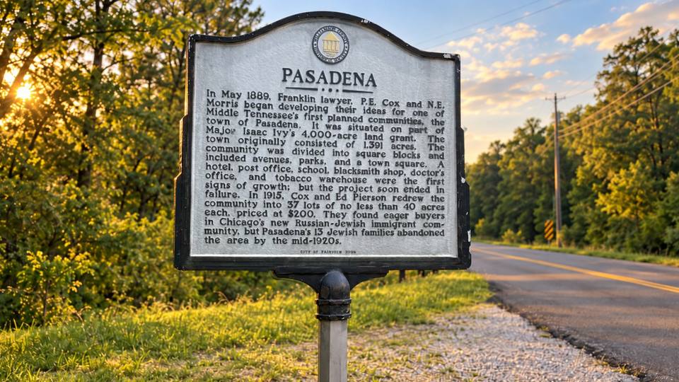
Horn Tavern Springs and Pasadena share a marker on Horn Tavern Road, near 7353, erected by the city in 2006. Two stories. Around 1809 a young man opened a tavern here on the road between Franklin and Charlotte, and hung a sign that gave the place its name: animals painted either side of the door, crowned with horns from elk, deer, ram, buffalo and oxen. The marker says the tavern was reportedly spared from burning during an attack because of that odd sign. The springs behind it, at the top of Brush Creek, were the city's main water supply from 1963 to 1991, good for a hundred thousand gallons a day. The second story is stranger. In 1889 a Franklin lawyer, P.E. Cox, and a partner named Morris set out to build one of Middle Tennessee's first planned towns on land carved from a four-thousand-acre grant. Pasadena was to have 1,391 acres of square blocks, avenues, parks and a town square, and it got as far as a hotel, a school, a post office, a blacksmith, a doctor and a tobacco warehouse before it collapsed. In 1915 the survivors of the scheme carved it into thirty-seven big lots at two hundred dollars each and sold them to Russian-Jewish immigrant families in Chicago. Thirteen families came. All had left by the mid-1920s.

Horn Tavern Springs and PasadenaOpen in Maps

3. The night a farmer named the town By Jingo

Jingo Post Office and Triangle School stand on Westview Boulevard north of Deer Ridge Road, another 2006 city marker, and this is the one that explains the town's old name. The First District's first post office opened in September 1839 under a postmaster named Isaac Toomey, and half a dozen others came and went after it. In 1880 a committee sat down to rename one of them and could not agree. The marker records what finally ended the meeting: "It's late. If you can't decide, By Jingo, I'm going home." That was the name for the next fifty-seven years. Jingo closed in August 1937, replaced by a post office on Highway 100 called Fairview, with Tella Mangrum keeping it. The old building was moved here in 2006. The other half of the marker is about the school that opened in 1939 with 115 pupils, on a three-acre triangular lot bought for $166.66 and built for $2,183.84 — figures worth reading twice. Its first principal, Nelle Walker Sullivan, spent fifty years teaching. Triangle, New Hope and Fairview schools merged into Fairview Elementary in 1962.

Jingo Post Office and Triangle SchoolOpen in Maps

4. The marker that says almost nothing

Triangle School has a marker of its own a few steps away, at 7121 Westview Boulevard, from the Tennessee Historical Commission. Its entire text is the name of the register it belongs to.

Triangle SchoolOpen in Maps

5. A graveyard that began with one son

Hudgins Cemetery and Union Valley are marked on Liberty Road near 7357, put up in 2010 by a Sons of Confederate Veterans camp. William J. Hudgins started the burial ground in 1876 when he buried his son Felix, and deeded it to the community in 1900. Neighboring families gave more land over the years. It now runs to five and a half acres and better than a thousand graves, with a chapel from about 1949 used for funerals and for Decoration Day. The marker names Confederate dead buried there, and notes veterans of both world wars, Korea and Vietnam. The Union Valley half is a school story: begun in 1871 inside a Methodist church, moved in 1900 onto land Hudgins gave, grown to three teachers and ten grades, and emptied in 1939 when its pupils walked over to Triangle.

Hudgins Cemetery and Union ValleyOpen in Maps

6. Fifty men to Franklin, and what it cost them

Marion's Rifles and Baxter's Company stand together at City Center Boulevard and City Center Way, outside the city buildings, from the historical society and the city in 2006. In May 1861 more than fifty men from this end of the county went to Franklin and joined Company H of the 20th Tennessee Infantry, which took the nickname. The marker lists where the regiment fought — Shiloh, Murfreesboro, Chickamauga, Franklin, Nashville and more — and then lists what it cost: twenty-five killed, fifty wounded, twenty-one dead of disease, fourteen taken prisoner. It was paroled in North Carolina on the first of May, 1865. The other half follows Captain Edmund Dillehunty Baxter, who spent six weeks here in the autumn of 1862 raising an artillery company and found more than a hundred men willing.

Marion's Rifles and Baxter's CompanyOpen in Maps

7. The woman who planted the park

Evangeline Bowie, M.D. is marked on Bowie Lake Road inside the park that carries her name, erected in 1997 by the historical society. Dr. Bowie lived from 1898 to 1992. The marker credits her with taking land it describes as a "washed-out, barren wasteland" and turning it back into woodland, then handing it to her neighbors. It names her sisters as well: Anna Bowie, a doctor too, whose head for money made it possible, and Thelma Byrd Bowie. "Ms. Van," as the marker calls her, directed the reclaiming and the planting. It ends by calling the park her legacy, which is about right for the 722 acres the city looks after now.

Evangeline Bowie, M.D.Open in Maps

Two more, just over the line

Two more markers sit close by, Fernvale and Flagpole Campground on Pinewood Road, both within a few miles although they are catalogued under other communities.

Seeing them all in an afternoon

Seen in one afternoon: the two on Westview Boulevard stand together, Marion's Rifles is outside the city buildings, and the Bowie marker is inside the park. The other three — Caney Fork Furnace, Horn Tavern Springs and Hudgins Cemetery — are out on country roads, and those are the ones worth the drive.

Sources: the inscriptions of the seven markers, as catalogued and photographed on the Historical Marker Database (hmdb.org). The markers were erected by the Williamson County Historical Society, the City of Fairview, the Tennessee Historical Commission, and Capt. Ed Baxter Camp 2034, Sons of Confederate Veterans.